Loading...
Searching...
No Matches
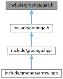
This graph shows which files directly or indirectly include this file:
Go to the source code of this file.
Classes | |
| struct | grn_geo_point |
Functions | |
| GRN_API grn_rc | grn_geo_select_in_rectangle (grn_ctx *ctx, grn_obj *index, grn_obj *top_left_point, grn_obj *bottom_right_point, grn_obj *res, grn_operator op) |
Select records within a specified rectangular area defined by the top_left_point and bottom_right_point parameters. | |
| GRN_API unsigned int | grn_geo_estimate_size_in_rectangle (grn_ctx *ctx, grn_obj *index, grn_obj *top_left_point, grn_obj *bottom_right_point) |
Estimate the number of records within a specified rectangular area defined by the top_left_point and bottom_right_point parameters. | |
| GRN_API int | grn_geo_estimate_in_rectangle (grn_ctx *ctx, grn_obj *index, grn_obj *top_left_point, grn_obj *bottom_right_point) |
| GRN_API grn_obj * | grn_geo_cursor_open_in_rectangle (grn_ctx *ctx, grn_obj *index, grn_obj *top_left_point, grn_obj *bottom_right_point, int offset, int limit) |
Create and return a cursor to retrieve records within a specified rectangular area defined by the top_left_point and bottom_right_point parameters. | |
| GRN_API grn_posting * | grn_geo_cursor_next (grn_ctx *ctx, grn_obj *cursor) |
| Retrieve the next posting from the cursor and advance to the next. | |
| GRN_API int | grn_geo_table_sort (grn_ctx *ctx, grn_obj *table, int offset, int limit, grn_obj *result, grn_obj *column, grn_obj *geo_point) |
Function Documentation
◆ grn_geo_cursor_next()
| GRN_API grn_posting * grn_geo_cursor_next | ( | grn_ctx * | ctx, |
| grn_obj * | cursor | ||
| ) |
Retrieve the next posting from the cursor and advance to the next.
- Parameters
-
ctx The context object. cursor The cursor from which to retrieve the next posting.
- Returns
- grn_posting if the next posting is found,
NULLotherwise. You don't need to free the returned grn_posting.
◆ grn_geo_cursor_open_in_rectangle()
| GRN_API grn_obj * grn_geo_cursor_open_in_rectangle | ( | grn_ctx * | ctx, |
| grn_obj * | index, | ||
| grn_obj * | top_left_point, | ||
| grn_obj * | bottom_right_point, | ||
| int | offset, | ||
| int | limit | ||
| ) |
Create and return a cursor to retrieve records within a specified rectangular area defined by the top_left_point and bottom_right_point parameters.
- Parameters
-
ctx The context object. index The index column for TokyoGeoPointorWGS84GeoPointtype.top_left_point The top-left point of the target rectangle. Its type must be one of the following: bottom_right_point The bottom-right point of the target rectangle. Its type must be one of the following: offset The starting position of the records to return (zero-based index). limit The maximum number of records to return. -1means no limit.
- Returns
- A newly opened cursor on success,
NULLon error. Seectx->rcfor error details.
◆ grn_geo_estimate_in_rectangle()
| GRN_API int grn_geo_estimate_in_rectangle | ( | grn_ctx * | ctx, |
| grn_obj * | index, | ||
| grn_obj * | top_left_point, | ||
| grn_obj * | bottom_right_point | ||
| ) |
- Deprecated:
- Since 4.0.8. Use grn_geo_estimate_size_in_rectangle instead.
◆ grn_geo_estimate_size_in_rectangle()
| GRN_API unsigned int grn_geo_estimate_size_in_rectangle | ( | grn_ctx * | ctx, |
| grn_obj * | index, | ||
| grn_obj * | top_left_point, | ||
| grn_obj * | bottom_right_point | ||
| ) |
Estimate the number of records within a specified rectangular area defined by the top_left_point and bottom_right_point parameters.
- Since
- 4.0.8
- Parameters
-
ctx The context object. index The index column for TokyoGeoPointorWGS84GeoPointtype.top_left_point The top left point of the target rectangle. Its type must be one of the followings: bottom_right_point The bottom right point of the target rectangle. Its type must be one of the followings:
- Returns
- The estimated number of records within the specified rectangle. Returns 0 if no records are found or if an error occurs. See
ctx->rcfor error details.
◆ grn_geo_select_in_rectangle()
| GRN_API grn_rc grn_geo_select_in_rectangle | ( | grn_ctx * | ctx, |
| grn_obj * | index, | ||
| grn_obj * | top_left_point, | ||
| grn_obj * | bottom_right_point, | ||
| grn_obj * | res, | ||
| grn_operator | op | ||
| ) |
Select records within a specified rectangular area defined by the top_left_point and bottom_right_point parameters.
- Parameters
-
ctx The context object. index The index column for TokyoGeoPointorWGS84GeoPointtype.top_left_point The top left point of the target rectangle. Its type must be one of the followings. bottom_right_point The bottom right point of the target rectangle. Its type must be one of the followings. res The table to store found record IDs. It must be GRN_TABLE_HASH_KEY type table. op The operator for matched records.
- Returns
- GRN_SUCCESS on success, the appropriate grn_rc on error.